Submitted by Alex Leith on Sat, 07/04/2015 - 14:16
Team Name:
MapMap
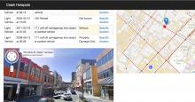
Tasmanian Crash Hotspots
Where do accidents happen a lot? What are the roads like in those areas? Is there a link?
There is a dataset of car crashes all over Tasmania, but it doesn't tell a story. Perhaps if we look at where the crashes are happening in terms of the piece of road that the occur on, we'll be able to identify problem intersections, or stretches of road, and better plan upgrades and mitigation efforts.
After much deliberation, and many blocked turns, our team finally nailed down a plan to develop an air conditioner recommendation application late on Saturday night.
Submitted by andrewwharton on Sat, 07/04/2015 - 11:46
Team Name:
ASDFG
Local, national and international (eventually) air quality rankings with daily, monthly and yearly winners.
The system is built on top of the Meteor web framework, using React templating and deployed on the Nectar cloud using a Docker container.
Near realtime data is pulled from various Environmental Protection Agency APIs in various formats and structures (CSV, XML etc.) and normalised into a common format which is then stored in a MongoDB datasbase.
Using Hansard history data on attendance and voting outcomes the project aims to create a gravity weighted graph to show how far apart and/or closely together individual MPs and parties vote on policy.
We chose the ABC broadcast data as we felt it was a data set that most people could relate to. Who hasn't spend an afternoon watching ABC?
Using our app users can pick a year and a state and get the most played shows between 3pm and 7pm. We use third party apis like thetvdb and youtube to give some interesting data about the show.
Does anyone really remember how their representatives vote in parliament?
Probably not.
Despite the existence of powerful web-based tools, like TheyVoteForYou and ABC’s Vote Compass, people often don’t know how their representatives are directing their votes.
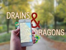
A mobile augmented reality game using local government datasets to create a simple 'Dungeons and Dragons' hack and slash fest. This is about raising awareness of bins as public assets.
Game Play
Connect to the game on your mobile device. As you walk around your area you will notice 'points of interest' appear on the map. Clicking on one of these will reveal the monster lurking at that point. What you do then is up to you (Fight, Flee or Find out more)
Submitted by daniel Sainsbury on Sat, 07/04/2015 - 09:06
Team Name:
ASDFG
Our team has implemented the Tap web and ios interfaces to the Hobart city council data loaded into tap-cms on a Ubuntu 14:04 nectar instance built for GovHack2015, after the competition started , particularly allowing people on the street to find and recognise and understand the art works catalqued by Hobart City Council.
in 2014 we partial completed this hack, The system was subsequently lost in a nectar upgrade. With little to go on we have reserected it, with DEM and metro routes and hopefully some bike tracks.
The issues were the many changes in OTP , java dependancies and configuration issues, the git source had to be modified, mostly in pom.xml as locatios of gtfs-lib had changed.